
GeoLens
Open-source, self-hosted catalog and map builder for geospatial data
Gallery
About GeoLens
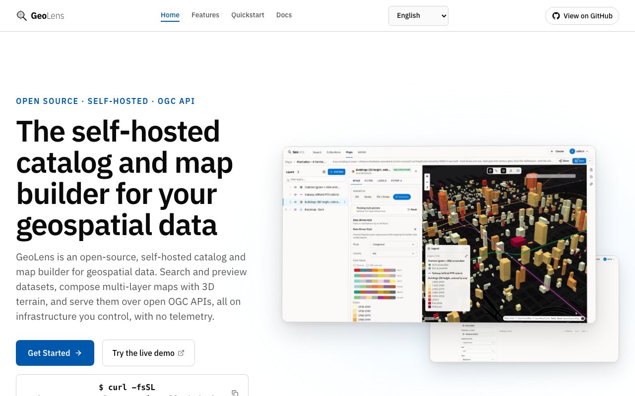
GeoLens is an open-source, self-hosted catalog and map builder for geospatial data. It gives a team one place to search their datasets, preview them on a map, compose multi-layer visualizations, and serve the results through open standards, all running on infrastructure they control. The gap it fills is the one between scattered spatial files and a usable internal map service. Most organizations sit on shapefiles, GeoTIFFs, and GeoJSON spread across drives and buckets, with no shared way to find what exists or turn it into something people can actually look at.
You start by ingesting data directly. GeoLens accepts shapefiles, GeoTIFFs, GeoJSON, GeoPackages, Cloud-Optimized GeoTIFFs, and CSV, detects the coordinate reference system automatically, and builds a spatial index so the catalog stays fast even as it grows. It also handles VRT mosaics, which lets you stitch many raster tiles into one logical layer without pre-merging them by hand. Once data is in, it becomes a first-class catalog entry rather than a file someone has to remember the path to.
Finding the right layer is where the catalog earns its keep. Full-text search covers dataset names and descriptions, and when GeoLens is configured with vector embeddings you also get semantic search that matches on meaning rather than exact wording, so a search for flood zones can surface a layer named something less obvious. On top of that you can filter by geometry type across vector, raster, and table data, by CRS, and by date range, which narrows a large collection down to the handful of layers that actually matter for the task in front of you.
The map builder is where the datasets become a picture. It's a drag-and-drop, point-and-click composer for stacking multiple layers, editing styles, applying color ramps, setting filters, and drawing features by hand. It handles 3D terrain with hillshade and adjustable exaggeration, so elevation-heavy data reads properly instead of flattening out into a plain fill. Finished maps can be shared through signed links or dropped into another page with embed code, which turns an internal exploration into something a wider audience can view without needing an account on the system.
Underneath the interface, GeoLens is built on open standards rather than a proprietary format. It exposes OGC API endpoints for Features and Records with CQL2 filtering, and it's compatible with STAC and DCAT for cataloging. Because it speaks those standards, it drops into existing GIS workflows and connects cleanly to desktop tools like QGIS and ArcGIS. That matters for teams that already have a spatial stack and don't want a walled garden bolted onto the side of it, since the same layers they browse in GeoLens are reachable from the tools they already use.
It's aimed at GIS teams, data engineers, and organizations that work with spatial data and want to keep it in-house. Role-based access control separates admins, editors, and viewers, so an analyst can publish while a wider group only views. OAuth integration supports Google, Microsoft, and generic OIDC providers, which means it plugs into whatever identity system a company already runs instead of maintaining a separate login. Comprehensive audit logging tracks what happened across the catalog, the piece that lets a tool graduate from one analyst's machine to something a whole department can rely on without giving up governance.
What sets it apart is the combination of self-hosting and open standards in one package. Plenty of hosted mapping platforms will catalog and visualize spatial data for you, but they keep the data on their cloud and speak their own dialect. GeoLens runs entirely on your own infrastructure, collects no telemetry, and requires no external cloud account, so sensitive or regulated geospatial data never leaves your control. The catalog and the map builder ship together as one system rather than as separate products you have to stitch together and keep in sync.
On access, GeoLens is free and open source under the Apache 2.0 license. You deploy it yourself with Docker Compose for a straightforward single-host setup or Kubernetes for a larger one, and there's a community Helm chart for the Kubernetes path. That means no per-seat fees and no usage metering, with the tradeoff being that you run and maintain the service yourself. For a team that already operates its own servers and wants a spatial data catalog it fully owns, that tradeoff is usually the whole point. Teams that would rather not run it can still read the code, audit exactly what it does with their data, and adapt it to fit, which is the kind of freedom an open license buys even when raw convenience is not the goal.
Key Features
- Multi-format geospatial ingest
- Automatic CRS detection and indexing
- Full-text and semantic dataset search
- Drag-and-drop multi-layer map builder
- OGC, STAC, and DCAT APIs
- Role-based access and OAuth
Pros & Cons
What we like
- Fully self-hosted with no cloud account
- Open source under Apache 2.0
- Speaks open standards like OGC and STAC
- Works with QGIS and ArcGIS
Room for improvement
- You host and maintain it yourself
- Requires Docker or Kubernetes knowledge
- Semantic search needs extra configuration
- Younger project with a smaller community
Frequently Asked Questions
What is GeoLens?
Is GeoLens free?
What data formats does GeoLens support?
Does GeoLens work with QGIS and ArcGIS?
Best For
Featured in
Alternatives to GeoLens

1Lookup
Real-time data verification API for phone, email, IP, and domain validation to fight fraud

Codedex
A gamified, story-driven platform that teaches Python, web dev, and more like an RPG quest
Hack2hire
Practice real SDE interview questions from top tech companies with expert worked solutions
Cloudflare Pages
Free Jamstack hosting on Cloudflares edge with unlimited bandwidth and tight integration with Workers.
Reviews (11)
Finally something that fits
Have been running GeoLens for a while, here is where I land. Where it really wins is automatic crs detection and indexing. Easy yes for anyone weighing the same trade offs.
Recommended without reservation
GeoLens solves a real problem for me without making a fuss about it. The automatic crs detection and indexing is more useful than I expected. The core workflow is smooth once you are set up. Mostly using it for keeping sensitive geo data on internal infrastructure.
It just works
Tried GeoLens on a side project first, then rolled it out everywhere. The interface stays out of my way, which I appreciate. Mostly using it for keeping sensitive geo data on internal infrastructure. It earns its place in my stack.
Good, with a few caveats
Hadn't planned on switching, but GeoLens was hard to ignore. Their take on full-text and semantic dataset search is genuinely good. It handles the boring parts so I can focus on the work that matters. Found it works best for composing multi-layer maps with 3d terrain. The catch is semantic search needs extra configuration. Worth it for what I get out of it.
Worth a look
Started using GeoLens casually, now it is pinned in my dock. What stands out is how it handles multi-format geospatial ingest. Easy yes for anyone weighing the same trade offs.
Worth a look
Three months of GeoLens later, here is what holds up. Got real value out of role-based access and oauth. It earns its place in my stack.
Pulled its weight from week one
GeoLens has quietly become part of my daily flow. Support actually answered when I had a question, which surprised me. The defaults are sensible, so I was not fighting settings on day one. It earns its place in my stack.
Pulled its weight from week one
GeoLens has quietly become part of my daily flow. It just works, day after day, without surprises. It fits well for serving geospatial data through standard apis. Glad I made the switch.
Pulled its weight from week one
Started using GeoLens casually, now it is pinned in my dock. Their take on speaks open standards like ogc and stac is genuinely good. Found it works best for cataloging scattered spatial datasets in one place. Recommending it to people in a similar spot.
Worth a look
Started using GeoLens casually, now it is pinned in my dock. Got real value out of multi-format geospatial ingest. No regrets so far.
Pulled its weight from week one
Came to GeoLens after getting frustrated with what I had before. What stands out is how little babysitting it needs. Worth it for what I get out of it.
Badge builder
Add GeoLens to your website
Choose a badge style and size, preview it here, then copy the generated HTML. Badge images are self-contained SVGs and do not require an external script.

<a href="https://toolindex.net/tools/geolens?ref=badge" target="_blank" rel="noopener">
  <img src="https://toolindex.net/badge/geolens/medium.svg" alt="GeoLens - Listed on Tool Index" width="180" height="50" />
</a>How to use the badge
- 1. Pick the style, size, and theme that fit your layout.
- 2. Copy the generated HTML from the code block.
- 3. Paste it into your footer, homepage, or press page.
Standard badge available
The standard listing badge is available now. Score and circle badges are limited to tools currently ranked in the top 10 of a category.
Badge clicks return visitors to this profile with a referral tag so the source remains identifiable.
Related Tools

Kevin Gabeci
Solo developer building web apps, cozy browser games, and AI creator toolkits.
Coolify
Self-hostable, open source alternative to Heroku and Netlify

Warp
The modern terminal reimagined with AI and collaboration

Bolt.new
Prompt-to-deployed full-stack app inside the browser
Work on GeoLens? Request listing access or correction