
CoordMap
Look up coordinates, elevation, distance, time zones, and other map data in a browser
Gallery
About CoordMap
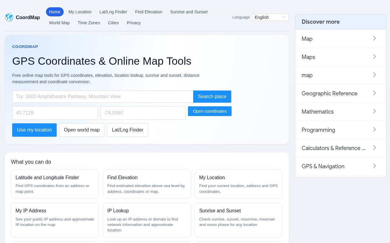
CoordMap is a collection of free browser tools for working with locations, GPS coordinates, maps, elevation, distance, and related geographic data. Its home page acts as a common starting point for tasks that would otherwise require several unrelated websites. A user can search for a place, paste a latitude and longitude pair, ask the browser for the current location, or open a specialized calculator. The tools run without requiring an account for core use, which makes the site practical for quick lookups and one off conversions.
The latitude and longitude finder can turn an address or a clicked map point into coordinates. The reverse workflow turns coordinates back into a street address when the geocoding data supports it. A world map lets users search or click to inspect places, while My Location shows the browser's current coordinates and address after explicit permission. CoordMap displays coordinates in WGS84, also known as EPSG 4326, and includes converters for decimal degrees, degrees minutes seconds, UTM, and MGRS. It doesn't apply the regional GCJ 02 or BD 09 offsets used by some map services.
Measurement tools cover both simple and multi-point work. Users can calculate straight line distance between places, add several points to a route style measurement, or draw points around a parcel to estimate area and perimeter. The elevation tool accepts an address or coordinate pair and returns an estimated height above sea level. That result comes from a local digital elevation model with roughly one kilometer resolution, so it is useful for orientation and comparison but not for surveying, construction, or any decision that needs precise ground measurement.
The site also brings contextual tools into the same interface. Sunrise and sunset pages can show solar times, moonrise, moonset, and moon phase for a location. Weather data is fetched separately when a user opens a weather view. Time zone, city, country, nearby place, public IP, and IP or domain lookup pages broaden the collection beyond coordinate conversion. IP locations are approximate at the city or regional level, as is normal for GeoIP data, and shouldn't be treated as a device's exact physical position.
CoordMap is transparent about the sources behind the results. Its map uses MapFirst tiles through MapLibre. Place and address searches use LocationIQ with Nominatim as a fallback, weather comes from WeatherAPI, and elevation is evaluated against a local digital elevation model. These sources have different limits and accuracy. Geocoding providers enforce fair use quotas, so searches may be rate limited, and a cached result may be used to reduce upstream requests. The site labels elevation as an estimate rather than presenting it as survey quality.
Privacy behavior depends on the tool. Browser geolocation starts only after the user clicks a location action and grants permission. Distance from the current position can be calculated in the browser, but address searches or reverse geocoding may send the query or coordinates to LocationIQ or Nominatim. Weather views send coordinates to WeatherAPI, and map tile providers receive ordinary requests tied to the visible map area and network address. Geocoding results may be cached. Only locations a signed in user explicitly shares become reachable through a public share link, while optional account history is private by default.
The broad tool set works well for travelers checking daylight, developers validating coordinate formats, property owners estimating a rough area, students exploring map concepts, and anyone who needs to move between an address and latitude or longitude. It is especially handy when the task is small enough that installing GIS software would be excessive. It is not a professional geographic information system, route optimizer, surveying package, or guaranteed source of current legal boundaries. Its strength is fast access to familiar global map utilities through one consistent site. CoordMap is free to use, and the public site doesn't present a paid plan. Core geocoding, elevation, map, conversion, and current location tools work without signing in. An account is needed only for optional private history and share management features. The tradeoff for free access is that upstream quotas can limit repeated searches and some results are necessarily estimates. For casual and lightweight professional lookups, the service offers a useful amount of geographic context with clear source notes and sensible controls around browser location permission.
Key Features
- Address and coordinate lookup
- Elevation and weather estimates
- Distance and area measurement
- GPS format conversion
- Sun and moon times
- IP and nearby place lookup
Pros & Cons
What we like
- Collects many map utilities in one site
- Core tools work without an account
- Documents its data sources and limits
- Requests browser location only after a click
Room for improvement
- Elevation is not survey grade
- Geocoding searches may be rate limited
- Coordinate display is limited to WGS84
- Some queries go to third-party providers
Frequently Asked Questions
What is CoordMap?
Do I need an account to use CoordMap?
Which coordinate system does CoordMap use?
How accurate is CoordMap elevation data?
Best For
Featured in
Alternatives to CoordMap

CalendHub
Smart scheduling and calendar management for teams
Kevin Gabeci Toolkits
Seven AI toolkits for writing books, making music, cutting video, and building agents.

Eased Into AI
Learn AI from zero. No jargon, no hype, just steps that work.

Fix It Gently
Calm, plain-English fixes for everyday tech problems.
Our take
Tool Index Editorial · Oct 2026· 4.0/5
CoordMap collects address lookup, GPS conversion, elevation, distance, area, daylight, weather, and IP tools in one free browser site. We found the breadth useful without feeling shapeless. A traveler can check sunrise, a developer can convert WGS84 coordinates to UTM or MGRS, and a property owner can sketch a rough area without opening a full GIS package.
The site is unusually clear about data sources and their limits, which matters here. Elevation is an estimate, IP location is approximate, geocoding can be rate limited, and some searches are sent to outside providers. CoordMap holds up well for quick checks, but it isn't a survey tool, route planner, or authoritative source for boundaries.
Editorial opinion from the Tool Index team, written from the public product pages. Not a user review.
Reviews (0)
Badge builder
Add CoordMap to your website
Choose a badge style and size, preview it here, then copy the generated HTML. Badge images are self-contained SVGs and do not require an external script.

<a href="https://toolindex.net/tools/coordmap?ref=badge" target="_blank" rel="noopener">
  <img src="https://toolindex.net/badge/coordmap/medium.svg" alt="CoordMap - Listed on Tool Index" width="180" height="50" />
</a>How to use the badge
- 1. Pick the style, size, and theme that fit your layout.
- 2. Copy the generated HTML from the code block.
- 3. Paste it into your footer, homepage, or press page.
Standard badge available
The standard listing badge is available now. Score and circle badges are limited to tools currently ranked in the top 10 of a category.
Badge clicks return visitors to this profile with a referral tag so the source remains identifiable.
Related Tools

Confluence
Atlassian's long-running team wiki that anchors many enterprise knowledge stacks
Asana
Project management for teams that live in projects, tasks and dependencies
Kevin Gabeci Toolkits
Seven AI toolkits for writing books, making music, cutting video, and building agents.

Logseq
An open-source outliner notes app where every bullet is a first-class block
Work on CoordMap? Request listing access or correction