
Flyover Country
Identify landscapes and landmarks from an airplane window without inflight internet
Gallery
About Flyover Country
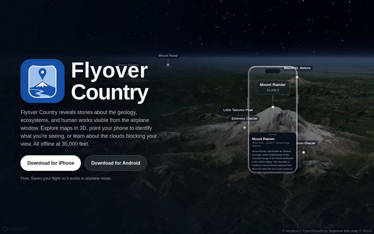
Flyover Country is a free iPhone and Android app that explains what is visible from an airplane window. It combines an offline flight map with stories about geology, ecosystems, landmarks, and human works along the route. Before takeoff, a traveler saves a flight and the related content to the phone. In the air, the app uses the device's location and the downloaded material to show what lies below without needing inflight Wi-Fi. It is built for the familiar moment when a river, mountain range, city, or unusual landform appears outside but the seatback map offers little more than the aircraft's position.
The app offers both map and camera-based ways to understand the view. Its three-dimensional map lets a traveler preview and explore mountains, glaciers, river valleys, and other terrain along the flight. Live view adds labels for rivers, parks, roads, airports, neighborhoods, and landmarks over the camera image. At night, a blend between the map and camera can help match waterways and city features to the pattern of lights below. A place can be opened for more context, turning the moving map into a guide rather than only a location tracker.
The three-dimensional view is useful before and during the trip. It gives terrain recognizable shape, which can make a glacier, mountain chain, or river valley easier to match with what appears outside. Nearby places can be opened from the map to learn about the landscapes coming up along the route. The live camera overlay then provides a second perspective when the ground is visible, while the nighttime blend helps connect mapped structure with scattered lights. Together, these modes support exploration instead of reducing the experience to a single moving aircraft icon.
Offline preparation is central to the product. A traveler chooses a route on the ground and saves the maps and stories needed for that corridor. Download options include satellite imagery, three-dimensional terrain, article images, and supporting content, with the expected size shown before saving. Once the flight is stored, the route can be explored in airplane mode. That workflow matters because the app is meant for the part of a trip where normal map tiles and web articles are unavailable or expensive to load.
Flyover Country also covers times when there is no clear ground view. Its illustrated cloud guide helps travelers compare visible formations and learn the difference between cloud types such as cirrus and stratus. The broader place material draws from open maps, scientific research, satellite imagery, and public knowledge. The project began at the University of Minnesota with support from the National Science Foundation, and its educational roots remain visible in the emphasis on landscapes, geology, and evidence-backed context rather than flight status or entertainment.
The app is a good fit for curious window-seat passengers, families turning a flight into a geography lesson, and travelers who want to identify places without buying inflight internet. It can also help someone preview the likely view along a route before boarding. The current product is available through both major mobile stores, so a mixed-device household can use the same basic experience. Its purpose is different from network flight trackers that show airport delays, gates, or other aircraft. Flyover Country concentrates on the user's own route and the world visible around it.
There are practical constraints. Offline maps and rich imagery must be saved before departure, and more detailed options consume additional device storage. Live positioning depends on the phone receiving a GPS signal inside the aircraft, which can vary with the device, seat, and conditions. The augmented reality view is most useful from a window seat with a visible horizon. It also cannot reveal the ground through solid cloud cover, though the cloud guide gives the app something relevant to offer when that happens. Travelers should complete the download on a reliable connection and confirm the saved flight before boarding.
Flyover Country is presented as completely free, with no paid tier mentioned on its site or store listing. Recent store information shows an actively maintained app with a rebuilt three-dimensional globe, augmented reality labels, offline maps and articles, and versions for iPhone, iPad, and Android devices. That makes it a mature, specialized travel companion rather than a general navigation service. It does one job especially well. It gives the person by the window an offline way to connect a real landscape to its name, shape, and story while the aircraft crosses it.
Key Features
- Offline flight maps
- Augmented reality labels
- Interactive 3D terrain
- Downloaded place stories
- Nighttime map blending
- Illustrated cloud guides
Pros & Cons
What we like
- Works without inflight internet after preparation
- Available on both iPhone and Android
- Combines maps with scientific and cultural context
- Completely free to download and use
Room for improvement
- Routes must be downloaded before takeoff
- GPS reception can vary inside aircraft
- Rich offline layers use device storage
- Live view works best from a window seat
Frequently Asked Questions
What is Flyover Country?
Does Flyover Country work in airplane mode?
Is Flyover Country free?
What can Flyover Country identify?
Best For
Featured in
Alternatives to Flyover Country

PropGPT
iOS app that uses AI to analyze player props, spreads, and bets across major sports leagues

Expo
The React Native framework and cloud build service that ships native iOS and Android apps without touching Xcode.

Glide
No-code platform that turns spreadsheets and databases into mobile and web apps, with computed columns and AI actions.

Fix It Gently
Calm, plain-English fixes for everyday tech problems.
Reviews (0)
Badge builder
Add Flyover Country to your website
Choose a badge style and size, preview it here, then copy the generated HTML. Badge images are self-contained SVGs and do not require an external script.

<a href="https://toolindex.net/tools/flyover-country?ref=badge" target="_blank" rel="noopener">
  <img src="https://toolindex.net/badge/flyover-country/medium.svg" alt="Flyover Country - Listed on Tool Index" width="180" height="50" />
</a>How to use the badge
- 1. Pick the style, size, and theme that fit your layout.
- 2. Copy the generated HTML from the code block.
- 3. Paste it into your footer, homepage, or press page.
Standard badge available
The standard listing badge is available now. Score and circle badges are limited to tools currently ranked in the top 10 of a category.
Badge clicks return visitors to this profile with a referral tag so the source remains identifiable.
Related Tools

Sleep Suivour
Track your sleep, improve your rest
Glide
No-code platform that turns spreadsheets and databases into mobile and web apps, with computed columns and AI actions.
ProtoPie
High-fidelity prototyping tool that simulates sensor input, IoT triggers, and complex interactions without writing code.

FlutterFlow
Visual builder that compiles to real Flutter source code, producing native iOS, Android, web, and desktop apps from one project.
Work on Flyover Country? Request listing access or correction